[Note added by SaveChatfield.org: The following letter about Chatfield Water Reallocation was shared with us by the Audubon Society of Greater Denver. It has been reformatted for presentation on the web.]
Col. Robert Ruch, Commander
US Army Corps of Engineers, Omaha District
Attn: Chatfield Reservoir Storage Reallocation FR/EIS
1616 Capitol Ave.
Omaha, NE68102-4901
Dear Colonel Ruch:
The following comments are submitted on behalf of the Audubon Society of Greater Denver (ASGD) and Save the Poudre: Poudre Waterkeeper on the Army Corps of Engineers’ (“Corps”) Chatfield Reservoir Storage Reallocation Draft Integrated Feasibility Report and Environmental Impact Statement (DEIS).
ASGD is a grassroots conservation organization based in Littleton, Colorado, with about 3,000 members in the Denver metro area. Our mission is to advocate for the environment through research, education and conservation. Save the Poudre is an organization of diverse people and groups joined together to protect the Cache la Poudre River.
Representatives of ASGD have been involved with the Chatfield Reallocation project for almost 10 years and have actively participated in the Chatfield “cooperators” meetings. While we commend the Corps, the Colorado Water Conservation Board and the project proponents for initiating the “cooperators” process, we must express frustration that most of our comments and concerns as expressed during the cooperators meetings, in emails to the Corps and in comments on the PDEIS were not substantively considered and addressed in the process leading to the DEIS. A genuine collaboration process goes beyond simply sitting at the table!
It is probably safe to say that initially all parties involved, including ASGD, thought that the impacts of the proposed Chatfield Reallocation would be fairly benign and the project relatively straightforward. In hindsight, perhaps, everyone should have been more sensitive to the fact that the project was proposed in one of Colorado’s premier State Parks.
Unfortunately, the perception, or misperception, that this is a benign project seems to have continued through much of the process even though it is now abundantly clear, as the DEIS documents, that the adverse environmental and recreational impacts are massive and some of the impacts very difficult, if not impossible, to fully mitigate.
In reading the DEIS and the Appendices, we found many inconsistent, if not outright conflicting, items of information among the Chapters in the DEIS and Appendices, as well as between some of the narrative statements and some tables and graphs. Furthermore, there are some critical deficiencies – a reservoir operations plan, an explicit discussion of the water rights to be stored, and a clear identification of the “safe” or “firm” yield of the project. These three deficiencies alone make an evaluation of the proposed project impossible.
Perhaps one consistent theme in the DEIS is an obvious bias toward the alternative supported by the water providers rather than the objective, impartial analysis required under NEPA (40 CFR 1502.1, Purpose “It shall provide full and fair discussion…”). A bias toward the “Preferred Alternative” is further supported by the various “policy exemptions” granted the project.
While it is clear that NEPA compliance is the Corps’ responsibility, it appears that the process and the contents of the DEIS were largely driven by the project proponents with limited oversight by the Corps, an Agency responsibility that goes beyond the individual project managers. Perhaps another manifestation of the perception that this was a benign project was the Corps assignment of staff project managers with limited experience in dealing with complex and controversial water projects and the requirements under NEPA. The fact that there were 4 project managers over the course of the NEPA process did not help in providing solid, sustained Corps leadership on such a complex project. This is NOT intended as a criticism of the project officers, as they were put in an extremely difficult situation that would have challenged even a seasoned veteran. Clearly the project is far more complex, has much greater impacts, and consequently is far more controversial than anyone initially envisioned.
More specific concerns and comments on the DEIS are contained in the following discussions. It is clear, however, that the discrepancies and the deficiencies in the DEIS, including violation of Federal statutes as well as the Corps’ own Planning Objectives and Planning Constraints, are of such magnitude that they can only be addressed through the preparation of a Supplemental DEIS (40 CFR 1502.9(c)).
Introduction
Chatfield State Park is one of the premier Parks in the Colorado State Parks system. It hosts more than 1.6 million visitor days per year and offers its visitors a wide range of activities such as bicycling, hiking, fishing, swimming, power-boating, kayaking, balloon launches, dog-training, scuba-diving, horseback riding, model airplane flying, picnicking, camping, bird watching, and wildlife photography. Situated at the conjunction of the foothills and the plains, and at the confluence of the South Platte River and several of its tributaries, it hosts a wide diversity of terrestrial and aquatic wildlife, all within a relatively short drive from the Denver metro area. Chatfield has been designated as an Important Bird Area by the National Audubon Society in recognition of its importance to breeding, migratory and wintering avian species. In short, Chatfield possesses rich and diverse biological and recreational resources.
ASGD agrees with Colorado State Parks (now State Parks and Wildlife) that “it is of the utmost importance that the longstanding, positive recreational experience provided at Chatfield State Park be maintained following the reallocation of any storage project”(Letter of Dean Winstanley, Director, to Gwyn Jarrett,10/4/2010). Since much of this positive recreational experience depends on the existing ecosystems and vegetation present at Chatfield, their maintenance is equally important.
The Feasibility Report/Draft Environmental Impact Statement released to the public on June 8, 2012, contains over 2,700 pages of text in the primary document (DEIS) and appendices. We have reviewed both, and have found them to be repetitive, confusing and often inconsistent. Information that is crucial to the project is hidden in obscure appendices; egregious statements of support for the preferred alternative are everywhere, and some critical information is missing completely.
To read and evaluate this massive document the Corps initially allowed only 60 days, disregarding the fact that many reviewers are volunteers working outside their regular paying jobs and that Corps Headquarters took over a year to review the draft. A 30-day extension was granted, but again this is too short for a document that is so long, a project that is so complex and a mitigation plan that is both complicated and essential to the success of the project. ASGD initially requested a comment period of 180 days and later, 120 days, but we have never heard directly from the Corps on either request.
I. The DEIS fails to meet the requirements of the National Environmental Policy Act for description of impacts, consideration of reasonable alternatives, disclosure of all relative information on the project, and taking a “hard look” at environmental consequences.
A. The description of impacts is partial, scattered and often misleading and the Corps violated NEPA by failing to disclose and discuss all relevant information for the Project.
NEPA ensures that relevant information will be made available to the public so that the public may play a role in both the decision-making process and the implementation of that decision. Robertson v. Methow Valley Citizens Council, 490 U.S. 332, 349 (1989). Congress sought to provide the public with the statutory means for being informed about (and commenting on) the environmental impacts of proposed agency action. Baltimore Gas & Electric Co. v.Natural Resources Defense Council, 462 U.S. 87, 97 (1993). “Action forcing” provisions within NEPA require federal agencies to examine and report on the environmental impacts of federal actions Ibid.
- The Corps violated its duty of full disclosure by hiding and not fully discussing the project’s dependable yield of zero and the nature of the water rights of the new water storage owners. Related to the water rights question is the basic matter of how much water the reallocation would actually provide. The standard metric for water supply planning is either “safe yield” or “firm yield” and not “average year yield” as is used in the DEIS . There are accepted methods for calculating “firm” and /or “safe” yield. Unfortunately, these do not appear in the DEIS or Appendices. Instead, buried in Appendix BB, “Project Waivers,” is a discussion of “dependable yield,” which seems similar to what is generally referred to as “safe” or “firm” yield. In this appendix the Corps notes that there are several “common measures of dependable yield…” and then concludes that “At Chatfield, all of those measures of dependable yield are 0.” This is a very significant conclusion that has critical implications for the project and should be noted in the Executive Summary as well as key points of the DEIS and not relegated to an obscure appendix that few individuals will ever read. It indicates that this project in fact cannot guarantee a reliable water supply beyond the small amounts of return flows already in existence. This conclusion is also stated in a Corps power point presentation (Corps of Engineers Water Supply Workshop, 2-4 June 2009, Tulsa OK, “Chatfield Lake, CO Cost of Storage for M&I Water Supply”). A full discussion of this critical fact is required for the Corps to comply with its full disclosure duties under NEPA.
The DEIS considers two types of yield, the yield from groundwater wells, which is dependable from year to year, and the yield from surface flows in the South Platte which depend on snow pack and rainwater. Comparing or adding the two is like adding apples and oranges. The discussion needs to differentiate between these two and use a common, consistent measure such as “firm” or “safe” yield.
To fully evaluate project impacts it is essential to describe the water rights (amount, location, and date) for each individual entity that seeks to store those rights in Chatfield Reservoir. The nature (especially the amount) of the usable return flows or what the Corps call “non-natural” flows also needs to be clarified.
We are told that the providers’ rights are very junior (PDEIS,. 2-4; DEIS pp. ES-9, 2-6 and 2-47, for example). The only place we could locate a partial description of the providers’ rights (surface rights, NTGW) and what they would be used for was in Attachment 1 to Appendix V, the PPRIP Biological Assessment (p. 6). Very few people will see this table.
There is speculation that some of the water providers are really seeking the Chatfield storage in order to transfer previously-undisclosed water rights or new rights to Chatfield. If that is, in fact, the ultimate intent, it must be fully disclosed in the NEPA document. Depending upon the nature of such transfers, the environmental impacts could be very significant beyond the impacts already at Chatfield. If this cannot be clarified, the Corps, should it approve the reallocation, must limit its approval to those water rights clearly identified in the NEPA documents and specify that any desire to store additional water in Chatfield would require a re-evaluation (this would be similar to what is occurring in the Corps’ public notice to modify the 404 permit for Rueter-Hess Reservoir).
The criteria for selection of alternatives in Chapter 2 states that “ To advance, concepts would not require the acquisition of water rights through new filings or by purchasing and transferring existing water rights from current water providers in a reasonably foreseeable time frame.”(P. 2-6). However a description of the project in Appendix V (P. 1) says reallocated space would be filled “using existing or new water rights.” (our emphasis). This is contrary to the statements just cited and also fuels speculation of the kind described above. As stated above, the water rights proposed for storage in the reallocation must be clearly defined to comply with NEPA’s requirement of full disclosure.
The fact that the providers’ water rights are very junior, dating from 1983 or later, has important implications for environmental impacts on the State Park and deserves full disclosure in the DEIS. It means that the providers’ water rights will rarely be in priority. The Corps has violated its duty for full disclosure due to the overall scattered organization and inconsistent information on actual water storage levels in the DEIS. An unorganized and inconsistent document leaves readers confused and unable to fully participate in the public process because they do not understand the full effects the project will have.
The providers will be able to fill the entire reallocated space at Chatfield “less than 50% of the time” (4-162); modeling suggests only 18% of the time (Table 2-9). During the growing season, when most inflows occur, water levels will rarely reach elevations of 5440’, 5441’ and 5442’, perhaps 1 year out of 8 (4-65). Enclosure 2 in Appendix BB suggests that the providers’ water will be available perhaps 3.5 years in 10. In dry years, absence of water will create barren mud flats, a bathtub ring, dust, and weedy areas (4- 76, 4-81), because lack of water will kill new vegetation trying to grow on the cleared ground. The description of such impacts is scattered through the DEIS and never discussed in depth in one place, certainly not in the Executive Summary where most readers will look. The DEIS needs to include a straightforward estimate of how often, and how much of the providers’ water will be available for storage, with the understanding that “inflows during the entire period of record tend to be greater, on average, than those expected for all alternatives” (4-90) and that therefore these estimates will be overly generous.
To comply with NEPA requirements of disclosure, it is necessary to fully describe the specific nature of the water rights to be stored at Chatfield and clearly disclose the “safe” or “firm” yield that the proposed project would actually provide. This should be done in a supplement to the EIS.
- The Corps failed to comply with NEPA by failing to take a “Hard Look” at the Environmental Consequences of the Project. NEPA ensures that the agency, in reaching its decision, will have available, and will carefully consider, detailed information concerning the significant environmental impacts. Robertson, 490 U.S. at 349. While NEPA does not require agencies to elevate environmental concerns above all others, it does require them to take a “hard look” at the environmental consequences before taking major action. Baltimore Gas, 462 U.S. at 97. “[T]he comprehensive “hard look” mandated by Congress and required by [NEPA] must be timely, and it must be taken objectively and in good faith, not as an exercise in form over substance, and not as a subterfuge designed to rationalize a decision already made.” Forest Guardians v. U.S. Fish and Wildlife Service, 611 F.3d 692, 712 (19th Cir. 2010) (quoting Metcalf v. Daley, 214 F.3d 1135, 1142 (9th Cir. 2000)).
The Corps violated its duty to take a “hard look” at the environmental consequences through its actions that showed the DEIS to be an exercise in form over substance. The Corps has shown a lack of receptivity to comments made by environmental, non-governmental organizations.as well as the State of Colorado. A lack of receptivity or concern to comments by those entities is evidence that the Corps is simply doing the DEIS to rationalize the decision it has already made. For example, the Corps has refused to provide visual representations of impacts, it has refused to consider alternatives such as increased water conservation, use of alternative existing infrastructure, or storage in other existing reservoirs, it disregarded information on bird species provided by a number of knowledgeable groups and it has failed to respond to concerns expressed by Colorado Department of Natural Resources and State Parks to maintain the quality of the recreational experience at Chatfield State Park (Winstanley, ibid).
Furthermore, the Corps has made numerous policy exceptions to even make the Chatfield Reallocation feasible: reduction in costs of storage, waiver of the requirement to build facilities above the 10-year flood pool, and lack of conformance with its own policies regarding 404 (b)(1) guidelines of the Clean Water Act (see Part II).
- The DEIS includes no Plan of Operations for the reservoir. This makes the discussion of impacts theoretical and some onsite mitigation measures difficult to evaluate. The reader needs a description (or at least a scenario) of when the additional water will enter the reservoir, at what point it will be taken out and by whom, how long water will be stored and resulting changes in water levels. A Plan of Operations was supposed to be delivered to the Colorado State Parks Board by July 2005 (report by Paul Flack to the Parks Board, 1/21/05), and it still has not appeared. If operations depend on conditions year-to-year, the Corps should at least provide scenarios for dry, average and wet years, as was requested by State Parks (letter of Dean Winstanley to Gwyn Jarret, 4/5/2010).
Since many of the impacts to riparian zones and trees could be alleviated or avoided by management of reservoir water levels, inclusion of a Plan of Operations is crucial. This deficiency must be remedied in a Supplemental EIS.
- The list of participants in the Chatfield Reallocation project in the DEIS does not reflect the current situation. Parker Water and Sanitation District, which withdrew years ago, is still listed as a participant in Appendix H; the City of Brighton has dropped out but is still listed in Table 1-1, as are Perry Park and Mount Carbon. The withdrawal of Parker and Brighton may well have changed the Reallocation’s impacts and should be reflected in a supplement to the DEIS.
- The DEIS does not mention the potential impact of the preferred alternative on the exercise of downstream rights on the South Platte River. The City of Littleton and the South Suburban Parks and Recreation District hold instream flow rights on the South Platte, which are “senior to many of the pending rights currently under adjudication by the water providers.” (Staff Comments to the South Suburban Parks and Recreation Board, 7/25/12). The discussion of downstream impacts is obscured by the fact that flow measurements quoted are from the Denver gage, approximately 15 miles downstream from Chatfield Dam, below the junction with several tributaries. The discussion would be more accurate if data from the gage at Chatfield or Littleton’s gage in South Platte Park were used. The impacts of the preferred alternative on South Platte River flows are described as negligible; but the mean annual outflow from the reservoir into the South Platte would be the smallest of all alternatives (4-36). South Platte Park is also an Important Bird Area designated by the National Audubon Society and ASGD is concerned about Reallocation impacts there. The DEIS should therefore discuss impacts on the exercise of downstream water rights and include data from gauges at Chatfield and South Platte Park. There should also be a discussion of the impacts of reduced instream flows on water quality and on jurisdictions which are discharging treated effluent into the river.
- No visual representations of the impacted areas in the State Park before project, at high water and at low water were included in the DEIS despite repeated requests by ASGD and the Sierra Club over several years. “A picture is worth a thousand words.” Visuals were finally put together for the public meetings but assumed regrowth of vegetation, including trees, on the lands below 5444’ that will be problematical given the water level fluctuations mentioned in various places in the DEIS. “The drawdown zone would be in a cycle of disturbance that would limit vegetation establishment to annuals, biennials, and short-lived perennials” (DEIS 4-57). These visuals are located on the Corps’ website but not in the DEIS. They are also misleading because the representations of current conditions used winter/early spring vegetative conditions, failing to show the full leaf-out of the trees and the shade and aesthetic satisfaction they provide to Park users. Thus the visuals show a better-than-average result while under-representing the current values of the Park’s tree-lined shores and riparian zones. ASGD has attached a set of visuals that we believe is actually more representative of conditions now, at potential high water, and at low water after vegetation is removed.
- The executive summary, which is the one section most people will read, contains an inadequate discussion of impacts, only stating that “it is difficult to say what the exact new condition of environmental resources at Chatfield will be, due to the expected but unpredictable high level of fluctuations of water levels” (ES-8). Here again the lack of a Reservoir Plan of Operations makes evaluation of impacts difficult, if not impossible, but the important point is that the public is only given references to the DEIS, whereas the point of the Executive Summary is to provide a summary WITHIN ITS OWN PAGES of the project’s major impacts, among other items. This Executive Summary lists all the supposed advantages of the preferred alternative, including costs, without revealing its impacts. It must be rewritten to include a statement of major impacts, for example acres of trees cut down, mature cottonwood forest lost, recreation facility relocation, loss of wetlands habitat, quantification of water level fluctuations and frequency as well as the “firm” or “safe” yield.
- The description of impacts in the DEIS and its Appendices are often inconsistent from section to section. For example the Tree Management Plan (Appendix Z) states that at least 243.5 acres of cottonwood trees and 52.8 acres of willows will have to be removed below 5439’ msl for various reasons. The Biological Assessment (App. V) says 43 acres of native cottonwood and 211 acres of other trees will be removed. The Plan also states that an additional 61.1 acres of trees might have to be cut down between 5439 and 5444 ft. msl. This brings the total of trees removed to over 300 acres. Table 4-8 however shows only 185.7 acres of cottonwoods and 16.7 acres of sandbar willow would be lost due to inundation under Alt. 3. Other figures given are 474 acres of vegetation removed and 587 acres lost to inundation (ibid), 586 acres of wildlife habitat inundated (4-80), 618.54 acres of habitat for birds and other wildlife lost (5-14), and 676 acres of wildlife habitat lost (4-80). These and other multiple figures make it impossible to judge both impacts and adequacy of mitigation.
Trees at Chatfield are primarily in riparian areas, and since riparian/birds are one of the CMP’s targeted environmental resources, we would have thought that consistent and accurate enumeration and description of the acres affected would be a priority in this DEIS. The Corps should ensure that these inconsistencies be eliminated or at least clarified.
- The description of downstream impacts in Chapter 4 text contradicts the information in Fig.4-12, p. 4-51. The figure shows slight negative impacts of Alt.3 on flows in the South Platte River 9 months out of 12, no impacts for 2 months and a slight positive impact in 1 month. Meanwhile the text discusses the benefits of increased flows in the summer months or during winter conditions which do not seem to be supported by the preferred Alternative. This contradiction is an important flaw in the DEIS and in the way Alt. 3 has been promoted to the public. The text should be rewritten to accurately depict the predicted impacts of reduced flows on the South Platte downstream of Chatfield.
B. A full range of reasonable alternatives was not seriously considered or discussed in depth in the DEIS.
Alternatives are “…the heart of the environmental impact statement.” (40 CFR Part 1502.14). Furthermore, it is the responsibility of the lead Federal Agency, in this case the Corps of Engineers, to “Rigorously explore and objectively evaluate all reasonable alternatives, and for alternatives which were eliminated from detailed study, briefly discuss the reasons for their having been eliminated.” (40 CFR Part 1502.14(a)).
The discussion of alternatives in the DEIS does not comply with the requirement to “objectively evaluate all reasonable alternatives” and appears to be more of an attempt to justify the alternative preferred by the project proponents and keep their costs low rather than an “objective evaluation.” Following are several clear examples of this biased analysis.
- Chatfield water providers’ water conservation programs were “eliminated” because “conservation measures alone would not meet the overall purpose and need of the project.” We are not aware that anyone has suggested that conservation, by itself, could meet all future needs. However, implementation of serious conservation measures, coupled with other alternatives (i.e. gravel pit storage, ground water recharge and recovery) could meet the purpose and need. While Appendix AA does describe the providers’ water conservation programs, many do not quantify either in terms of gpcd or acre-feet, the water savings associated with their programs. The “SWSI Conservation Levels Analysis Final Report” prepared for the Colorado Water Conservation Board (Great Western Institute, June 2010) discusses the challenge of evaluating the effectiveness of existing conservation programs. Water conservation received the support of, among others, Colorado Trout Unlimited in their scoping comments (summary of scoping comments, App. S).
Agencies cannot disregard alternatives merely because they do not offer a complete solution to the problem. Davis v. Mineta,, 302 F.3d 1104. 1122 (10th Cir. 2002); Natural Resources Defense Council v. Morton, 458 F. 2nd 827, 836 (D.C. Cir. 1972). Thus the Corps violated the NEPA requirement to explore all reasonable alternatives when it eliminated the increased water conservation alternatives, including the Chatfield Water Providers M&I Conservation Programs and the Central Colorado Water Conservation District Efficiency Programs, from further consideration (DEIS, p. 2-28). Its rationale for elimination states that “the water shortages…faced by the water providers…will not be resolved by water conservation measures alone and therefore water conservation is not an equivalent practicable alternative to the proposed project” (2-16). The water conservation programs work toward the purpose and need of the project by lowering the demands for water, thereby alleviating a significant portion of the environmental harm storing more water would cause. Because the Corps does not have an adequate reason for eliminating the water conservation alternatives, it needs to explore them even if it is in conjunction with other alternatives discussed below.
Another glaring weakness in the DEIS and Appendix AA is the lack of discussion of how water conservation programs integrate with the project proponents’ over-all water supply planning efforts. Given the recognized limitations on water supply, increasing demands, and the impacts of climate change, there is universal recognition that serious water conservation must be an integral component of water resources management. This is a major deficiency in the DEIS which should be corrected in a Supplement which clearly quantifies the providers’ water conservation programs and discusses how these programs fit into their water supply planning portfolios.
Increased water conservation may not in itself solve Front Range water supply shortages but it is an important component of future water supply plans. Even the sample “Resolution of Support” in the packet sent to all the providers by Capitol Representatives for them to present to their Boards and City Councils includes “aggressive water conservation measures” in the mix of strategies for Front Range water supply (email from David Howlett. Capitol Representatives, June 2012). We know that water conservation can have dramatic effects. For example, a September 2010 brochure from Denver water states that its customers are using 19% less water than they did before the drought of 2002, despite population increases.
- The Chatfield area contains a tremendous amount of “water infrastructure” (dams, diversions, pipelines, reservoirs, gravel pits, etc.) which should have been evaluated as potential alternatives to Chatfield storage (see email greetz to Gwyn Jarrett, Feb. 22, 2011). It is not unreasonable to think that some combination of these facilities could be less environmentally damaging than Chatfield. Bias in application of the screening criteria seems to have eliminated consideration of such an alternative (i.e. gravel pit storage is OK for downstream entities but was eliminated for upstream entities).
- ASGD also suggested (email greetz to Gwyn Jarret, Oct. 17, 2011) that Project WISE (which could eventually provide 60,000 acre-feet per year) and storage in Rueter-Hess reservoir (email greetz to Gwyn Jarret, Feb. 22, 2011) should be evaluated as possible alternatives to Chatfield. However, both those were eliminated without substantial analysis, a clear indication of bias towards the “preferred” alternative. Interestingly, Fig. X-X in Appendix S (Attachment to letter of USACE, Feb. 29, 2008 to Georgiana Contiguglia, CO Historical Society) shows a proposed pipeline from Chatfield to Rueter-Hess reservoir as part of Alternatives 1, 3 and 4.
In eliminating Project WISE water and storage in Rueter-Hess, the DEIS completely ignores the fact that a number of the providers who seek storage in Chatfield have also applied to store Project WISE water in Rueter-Hess (NWO-1997-80472-DEN). In response to this pubic notice, ASGD (letter December 26, 2011 from Arlene Raskin, President ASGD to Chandler Peter, CoE) stated that “…it is critical to evaluate if the WISE/Rueter-Hess proposal could reduce or eliminate the need for additional Chatfield storage.” And, “Since the Corps of Engineers has lead responsibility for both the proposed permit amendment to the existing 404 permit for Rueter-Hess Reservoir and the Chatfield Reallocation study, we assume that the Corps will closely coordinate these two proposals to insure that water supply needs can be met in the least environmentally damaging way…”
The link between some Chatfield providers and Project WISE water storage in Rueter-Hess and storage in Chatfield has been ignored in the DEIS. The relationship between these two efforts must be addressed.
Storage in Rueter-Hess Reservoir was dismissed because “Parker WSD has no plans to make this reservoir available” (Table 2-4, P. 2-30). No evidence is given that the providers discussed Rueter-Hess water storage with Parker WSD except this brief negative statement, and the statement is contrary to published reports on Rueter-Hess: "The 45,200 ac.-ft. excess capacity [above needs of Parker, Castle Rock, Castle Pines and Stonegate] will be available for sale, the revenue of which will help reduce PWSD debt." (Colorado Public Works Journal, Vol 6, Issue 3, January 2010). This excess capacity is over twice the storage space requested in the preferred alternative of the Chatfield Reallocation.Further, "PWSD, having always envisioned the project [Rueter–Hess] as ultimately benefitting [sic] the region and not just the District, reasoned to the other water providers that if they were really interested in becoming partners, the expansion should be implemented immediately to save overall cost." (Ibid) As of March 2012 three of the Chatfield providers - Castle Rock, Castle Pines North and Stonegate Village – owned 11,000 af of storage capacity in Rueter Hess (Denver Business Journal, March 21, 2012).
The Corps cannot eliminate reasonable alternatives simply because they require action by entities outside itself. Morton, 458 F. 2nd at 836. Thus the Corps violated NEPA when it eliminated the Rueter-Hess, South Platte, McLellan and Platte Canyon Reservoirs due to the owners having “no plans” to make it available. This is analogous to the situation in Morton because it would require action by entities outside of the Corps. Because the Corps reasons for eliminating storage in Rueter-Hess and other Reservoirs are insufficient they are in violation of NEPA and must discuss the topic in a Supplemental EIS.
NEPA requires agencies to briefly discuss the reasons for eliminating alternatives from detailed study. 40 CFR § 1502.14(a). EIS’s have been deemed insufficient when their reasons for eliminating alternatives are too brief and perfunctory. Village of Palatine v.U.S. Posta. Service, 742 F.Supp.1377, 1382 (N.D.III 1990). The Corps has provided reasons that are too brief and perfunctory for eliminating alternatives as in the above cited case. As was already discussed, the fact that an alternative does not, standing alone, fulfill the purpose and need is not reason to eliminate it. Outside of that reason for eliminating the increased water conservation alternatives, the Corps simply states that the alternatives constitute independent parallel action that would occur with or without the Chatfield expansion (DEIS, 2-23). This brief explanation does not satisfy the requirement of NEPA that the Corps discuss the reasons for eliminating the alternative.
- Aquifer storage and recharge should be part of an alternative but are not discussed in depth. This is a proven technique; Centennial WSD was already employing it to store 14,042 acre-feet using 18 wells as of December 2010. Denver Basin aquifers offer viable storage possibilities, there are no production losses, no observed effects on aquifers and minimal capital costs. (J. Hendricks, General Manager, presentation at American Water Resources Association luncheon, December 2010). Underground storage avoids the water losses to evaporation which are a major drawback of the “preferred alternative.” An alternative that includes it might have to include more pipelines and treatment facilities (see Criterion LT-5, Table 2-1, p. 2-10) but Alt. 1, 2 and 4 would also require such facilities and were not eliminated for that reason. Thus the failure to include an alternative with this component is a major deficiency of the DEIS.
The Corps also does not provide a reason it cannot evaluate the several alternatives, together, that were deemed to not satisfy the purpose and need of the project standing alone. Water conservation programs, along with storage in existing reservoirs, gravel pit storage and aquifer storage and recharge are reasonable alternatives that the Corps needs to objectively evaluate in a Supplemental DEIS.
- Another example of inconsistencies and bias is in the evaluation of the yield of the 4 alternatives selected for detailed analysis and which meet the “purpose and need.” The amount of water in the Denver Basin aquifer system is enormous: “Current estimates are that the basin contains over 200 million acre-feet of recoverable water in storage.” (Colorado Foundation for Water Education. 2007. “Citizen’s Guide to Denver Basin Groundwater.”) Hence pumping of non-tributary groundwater is a “safe” or “firm” yield for the period of analysis. It is estimated that at the permitted authorized pumping rate of as much as 350,000 acre-feet per year, “the 200 million acre-feet of water in storage would last approximately 570 years” (ibid). The current discussion puts yield from groundwater (wells), which is reliable year to year, on the same level as yield from snow melt and rain water, which is notoriously variable. This is like comparing apples to oranges. All the alternatives should be evaluated based on a “firm” or “safe” yield so they can be appropriately compared.
- Corps personnel evidently endorsed the project years before the writing of the DEIS. “If we can lower the antecedent flood (inflow design flood) by 10% we can carve out the 20,600 AF additional storage space” (comments of by Doug Clemenson, USACE, Minutes of Cooperators meeting, 6/22/05). At best this is cheerleading for the project, at worst an indication that data would be manipulated to reach the desired result. In fact the antecedent inflow design flood was lowered from 50% to 40%. This is yet more evidence of bias in favor of the providers’ preferred alternative.
- Study-specific Planning Objectives and Planning Constraints were ignored in considering alternatives. The very first “Planning Objective” (2-6) states, in part, “Increase availability and reliability of water supplies…” yet the Corps concludes (App. BB) the project has “low reliability” and also, “At Chatfield, all those measures of dependable yield are 0.” Violating a critical planning objective is another example of bias toward the project preferred by the water providers.
Other constraints listed in Chapter 2 include “Maintain the conservation pool in Chatfield between 5,423 ft. msl and 5,432 ft. msl…” Alternatives 3 and 4 violate this study-specific constraint, which suggests they should not even have been considered. Existing contracts between the State and both the United States and Denver for the regulation of water storage between elevations 5,423 feet and 5,432 feet “are an absolute constraint on any proposals that may affect the elevation of the water stored in Chatfield Reservoir.” (letter of Grady McNeill, CDOW and Bahman Hatami, DPOR, 8/5/09). We have found no evidence in the DEIS that this contract has been addressed.
- Penley reservoir is not a realistic alternative for upstream providers. Strong local opposition and reported geologic faults and soil conditions in the area may make this dam site infeasible. The Douglas County Planning Commission voted 8-0 against a permit for construction of this dam. This feature should be re-examined and another official “no action” alternative devised. It appears as though Penley Reservoir was thrown up as a “straw man” to ensure an adequate number (though not quality) of alternatives and favorable support for the “preferred” alternative.
- The DEIS does not mention who developed the Criteria for selection of alternatives in Chapter 2 but they were obviously designed for the benefit of the project proponents and not to promote an objective consideration of alternatives.
- The comparison of costs of the alternatives is biased in favor of the preferred alternative. Reasons for this conclusion include:
a. The Corps is charging the providers only 41% of the cost of storage (see Appendix BB). A Power Point presentation given by the Corps at a Water Supply Workshop in Tulsa, OK June 2-4 2009 clearly lays out the rationale for this strategy, which makes the preferred alternative look $20 million cheaper than the low cost alternative (#2). If the true cost of storage were included, the cost of the preferred alternative would be at least $204.4 million (power point available at www.corpsresults.us/docs/CleanWaterSupplyWorkshop).
b. The Corps waived the requirement to build the relocated recreational facilities above the 10-year flood pool, which reduces the costs of dredging and filling for Alt. 3 (App. BB).
c. Weighting factors in the Ecological Functions Approach for off-site mitigation lead to a reduced acreage for mitigation and thus to lower costs for Alternative 3.
The biases in the evaluation of alternatives and the glaring omissions can only be addressed through a revised and objective analysis of alternatives in order to comply with CEQ regulations. It is also critical that alternatives be evaluated based on a “firm” or “safe” yield and not on an “average” yield so there can be a true comparison of what they can actually provide. The Corps needs to exercise its responsibilities and leadership, as well as expertise, and not let the NEPA process be driven by the project proponents. The current “preferred” alternative is BY FAR the most environmentally damaging alternative and it is inconceivable that there are not less environmentally damaging ways of meeting the “purpose and need.”
In conclusion, the Corps has failed to discharge its duties under NEPA because it 1) does not fully disclose all relevant information about the project, 2) does not take a “hard look” at environmental consequences, and 3) does not explore all reasonable alternatives. We recommend that a Supplemental EIS be issued that includes an alternative that incorporates increased water conservation, storage of water in gravel pits, aquifer storage and recharge, and use of Reuter Hess reservoir (e.g. in Project Wise). It should also evaluate alternatives based on “firm” or “safe” yield and eliminate biases in the cost estimates of alternatives. It should also clearly specify the exact water rights proposed for storage in Chatfield Reservoir.
II. The project as described in the DEIS does not comply with the Clean Water Act.
One of the most serious flaws in the DEIS is the incorrect application of Section 404 of the Clean Water Act. While the Corps does not issue 404 permits for its own activities, Corps regulations clearly state that the Clean Water Act Section 404(b) guidelines do apply.
As stated in the Corps’ regulations 33CFR Section 335.2 “…the Corps does not issue itself a CWA permit to authorize Corps discharges of dredged material or fill material into U.S waters, but does apply the 404(b)(1) guidelines and other substantive requirements of the CWA and other environmental laws.”
Similarly, 33 CFR Section 336.1 states “(a) Applicable laws. Section 404 of the CWA governs the discharge of dredged or fill material into waters of the U.S. Although the Corps does not process and issue permits for its own activities, the Corps authorizes its own discharges of dredged or fill material by applying all applicable substantive legal requirements, including public notice, opportunity for public hearing, and application of the Section 404(b)(1) guidelines.”
Furthermore, the Corps’ Planning Guidance Notebook (Engineer Regulations 1105-2-100) elaborate on the requirement for compliance with the 404 (b)(1) guidelines. As stated in C-6, “Water Quality and Related Requirements”:
“a. Purpose. This section provides guidance for the consideration of water quality and related programs in Civil Works planning studies…
c. Conducting the Section 404(b)(1) Evaluation in the Planning. During feasibility planning, District commanders shall conduct and, to the fullest extent practicable, complete the investigations and analysis required by the Section 404(b)(1) Guidelines. Water quality and related information used in the evaluation will provide documentation to demonstrate that the recommended plan is in compliance with the Clean Water Act.
d. Clean Water Act: Section 404. Feasibility report recommending projects involving the discharge of dredged or fill material in the waters of the United States, including wetlands, shall be developed consistent with Section 404(b)(1) Guidelines…..
e. Section 404(b)(1) Evaluation Documentation. District commanders shall include in their feasibility planning report, analysis and documentation necessary to demonstrate that the recommended plan is in compliance with the 404(b)(1) Guidelines…”
The Guidelines require the Corps to examine practicable alternatives to the proposed discharge and only allow it to issue permits for the Least Environmentally Damaging Practicable Alternative (LEDPA). Memorandum of Agreement Between the Department of the Army and the Environmental Protection Agency: The Determination of Mitigation Under the Clean Water Act Section 404(b)(1) Guidelines (MOA). The LEDPA is determined by evaluating the direct, secondary, and cumulative impacts on the ecosystems of each proposed alternative. The Federal Wetland Permitting Program: Avoidance and Minimization Requirements.
The Guidelines emphasize that avoidance of impacts is the first step and prohibit a discharge if there is an alternative that will do less damage to the aquatic ecosystem.Additionally the Corps must clearly demonstrate that the alternatives that do not require a discharge of dredged or fill material in the waters of the U.S. are either not practicable or have other adverse environmental consequences. Before the Administrator, United States Environmental Protection Agency, Subject: Draft Environmental Impact Statement for the White Pine Energy Station Project, Nevada 2007 WL 7398139 (E.P.A.) The Corps’ decision to choose Alternative 3 and allow discharge of dredge and fill materials into the waters of Chatfield State Park is a direct violation of the Guidelines. That Alternative is not the Least Environmentally Damaging Practicable Alternative and could be avoided altogether by choosing a different proposed project alternative (DEIS, 2-45-15). The Corps failed to meet its burden of proving that all other options were not practicable or had other adverse environmental consequences. The evidence in the DEIS is that Alternative 3 is not only not the LEDPA, it is in fact the MOST damaging alternative (Table 2-9).
The Corps improperly excluded alternatives from its preliminary list that should have been considered and analyzed in depth. ASGD believes that the least environmentally damaging alternative would be a combination of aggressive water conservation, gravel pit storage, aquifer storage and recharge, and storage in Rueter-Hess reservoir. This combination was not analyzed in detail yet would result in the avoidance of discharging dredge and fill material into the waters of Chatfield State Park. The Corps should re-evaluate its decision due to its obligation to choose the Least Environmentally Damaging Practicable Alternative under the 404 (b)(1) guidelines and take into account the multitude of ways that the broad project purpose could be achieved.
- Alternative 3 is a Single Project and Must be Analyzed as a Whole. Appendix W, “CWA Section 404(b)(1) Analysis Dredge and Fill Compliance,” under 2.2 provides a “general description of dredge and fill activities” and then incorrectly states that these activities are “…incidental to the proposed reallocation.” These activities (relocation of recreation facilities, on-site environmental mitigation, and off-site mitigation for impacts to Preble’s meadow jumping mouse) are clearly not “incidental” but are essential components of the reallocation plan.
It is absolutely inconceivable that the Corps would authorize the reallocation without these elements of the project. Furthermore, it is Corps policy to look at a single and complete project and not to segment individual components. The Corps has used a “but for” analysis to determine what is a complete project. In the case of the Chatfield reallocation, the relocation of recreation facilities, on-site environmental mitigation and off-site mitigation for Preble’s mouse, would NOT be needed but for the reallocation. Therefore, those activities are a requirement of the reallocation and should not be separated from the reallocation. Furthermore, Section 116 of the Omnibus Appropriations Act of 2009 (P.L. 111-8) identifies responsibilities of the Colorado Department of Natural Resources and notes, “..and any required mitigation which results from implementation of the project.” Clearly mitigation is a requirement and not an “incidental” part of the project.
NEPA explicitly states that agencies must consider connected actions when determining the scope of an EIS. 40 CFR § 1508.25. Connected actions must be analyzed as a whole and are those that “[a]utomatically trigger other actions which may require environmental impact statements…[c]annot or will not proceed unless other actions are taken previously or simultaneously…[or][a]re interdependent parts of a larger action and depend on the larger action for their justification.” Ibid.
The Corps incorrectly tries to segment the Chatfield Reallocation plan. Segmentation is an attempt to avoid environmental regulation by dividing one project into smaller projects and not analyzing the impacts of the project as a whole. Stewart Park & Reserve Coal, Inc. (SPARC) v. Slater, 352 F.3d 545, 559 (2nd Cir. 2003). “Segmentation is to be avoided in order to insure that interrelated projects, the overall effect of which is environmentally significant, not be fractionalized into smaller, less significant actions.” Town of Huntington v. Marsh, 859 F.2d 1134, 1142 (2nd Circ. 1988). A project should not be segmented if it “has no independent utility, no life of its own, or is simply illogical when viewed in isolation.” Op.cit. Segmentation is inappropriate because the Reallocation and mitigation have “no independent utility, life of [their] own, [and are] simply illogical when viewed in isolation.”
It is essential that the Corps redo the 404(b)(1) analysis for the complete project and that this be available for public review and comment in a Supplemental DEIS.
- Alternative 3 may violate the Clean Water Act because it destroys Preble’s Meadow Jumping Mouse Critical Habitat. The Clean Water Act prohibits discharge of dredge or fill material if it would likely result in the destruction or adverse modification of a critical habitat. 40 CFR § 230.10(b)(3). “Destruction or adverse modification means a direct or indirect alteration that appreciably diminishes the value of critical habitat for both the survival and recovery of a listed species.” 50 CFR § 402.02.
The proposed Reallocation will inundate over 456 acres of Preble’s habitat, of which more than 155 acres is critical habitat (DEIS 2-72). The discharge of dredge and fill material will be employed to accomplish the recreation relocation and mitigation components of Alternative 3 (DEIS, W-5). Since all of the components of Alternative 3 are connected, there is no Alternative 3 without the relocation and mitigation components, and there is no relocation and mitigation without dredging and filling. Although the US Fish and Wildlife Service will make a determination on adverse modification in its Biological Opinion, we want to call attention to these provisions of the Clean Water Act.
III. The project does not comply with the Corps own Planning Objectives and Constraints:
- The Planning Objectives (p.ES-5) include “fully mitigating unavoidable significant impacts” and “minimizing environmental impacts”. In fact the preferred alternative causes unavoidable significant impacts: loss of mature cottonwood forest, loss of free-flowing stream segments, and loss of 587 acres of publicly-accessible land in the Park. These cannot be mitigated and are a net loss. See our discussion of mitigation in Part V for further details. Therefore the Corps is not complying with this Planning Objective.
The preferred alternative is the most environmentally damaging one (see Table 2-9) of those considered; minimizing environmental impacts would require approval of another alternative (see discussion in Part I).
The first “Planning Objective” listed is “Increase .. reliability of water supply…” See our discussion under Part I, Alternatives, Study-specific Constraints.
One of the “Planning Objectives” is “Become less reliant on non-renewable ground water by utilizing renewable water supplies, thus extending the availability and life of these critical aquifers for use by future generations.” In order to achieve this commendable planning objective, should the Corps approve the reallocation, it is essential that there be a legally binding agreement between either the water providers and the Corps, or the water providers and Colorado DNR that the providers would, in fact, reduce ground water pumping in an amount equal to water they derive from Chatfield storage. Absent such an agreement, Chatfield storage would simply be used for additional growth with no reduction in ground water pumping.
- Constraints include “the project should not rely on the use of others’ land or on their project capability” (ES-5). This is also a study-specific constraint (P. 2-6). Mitigation (a part of the project) of the loss of wetlands, bird and Preble’s mouse habitat calls for land acquisition in fee simple or conservation easements on private lands – others’ lands. The mitigation for Preble’s habitat in the South Platte River Critical Habitat Unit is on US Forest Service land and involves redesign of a Douglas County road. The DEIS does not say who owns the right of way but it is certainly not held by the Corps. We are not sure what this constraint actually means – the project should not rely on private lands? On lands of other federal, state or local agencies?
Constraints also include “public acceptability” but the providers and the Corps have made little attempt to engage a broad spectrum of the public to determine “acceptability” of the project. Most of the testimony at the public meeting of 6/26/2012 strongly opposed the Reallocation. The Chatfield providers have used a coordinated PR effort to solicit local government support but this differs radically from an open and honest public discussion of project impacts. Penley Reservoir, part of Alternative 1, is strongly opposed by local residents and was voted down unanimously by the Douglas County Planning Commission, hardly an indication of public acceptance.
IV. The DEIS contains incomplete resource information that biases evaluation of impacts.
- Wildlife species that occur in the Park have been left off the species list in App. F. See letters submitted by J. Kellner and by H. Kingery to the Corps for the public record. Reptile and amphibian species that occur in the Park have also been left off the species list in App. F. ( testimony by J. Farah, 6/26/12.). The northern leopard frog is not included in Appendix F. However there are numerous records of its occurrence at Chatfield (Farah, ibid) and the US Fish and Wildlife Service (FWS) has stated that “it is know to exist in the project area” (FWS Planning Aid Letter to Candace M Gorton, Feb, 2006). Some impacts on this species are discussed in Chapter 4.and in fact the northern leopard frog is included in Table 3-5. These inconsistencies need to be resolved.
- Some information is just wrong and is obviously not based either on field work or on the extensive records submitted by Kellner and others (cited p. 3-50). The DEIS says that Great horned owls and red-tailed hawks “can be sensitive to human disturbance so nests may be uncommon.” In fact they are common, and the birds frequently nest in places with substantial human use (Kingery, ibid.). One nest occupied alternately by red-tailed hawks and great horned owls is close to the Colorado Trail and visible from the Audubon Center. These species nest in the type of large trees that will be removed under Alt. 3. The great horned owl is listed as a woodland dominant (P. 3-51) despite the statement that nests may be uncommon on P. 3-47. These two statements seem contradictory.
A close examination of the records of bird species observed in the park in breeding, migration and wintering seasons must be done and accurately reported in the DEIS. The current inaccuracies result in an understatement of biological resource values of bird species and influence the Ecological Functions Approach and mitigation plan.
- The data on which estimates of species abundance, species richness and species diversity were based were collected during point counts on only two mornings of two days in one year. The DEIS states that “the findings in Table 3-3 are based on one season of field data…..Additional years of field data would increase precision” (p. 3-50). This sentence gives the impression that data collection occurred repeatedly over the field season, rather than on just two mornings late in the nesting season. The Reallocation study has been going on for many years and the failure to collect more field data could be construed as yet more evidence of bias towards the preferred alternative. (including no allocation of funds for more field work). The use of information submitted by the sources cited on P.3-50 which include winter, spring and fall counts, would also have increased precision and they should have been used in calculating the estimates in Table 3-3. Despite the reference to “information from Audubon Society of Greater Denver” (p. 3-50) we do not know if the point count data were in fact amplified by that information (what information, exactly?) to determine Species Richness, Species Abundance, and Species Diversity in that Table. We feel these figures under-represent the bird resource at Chatfield and bias the mitigation process.
The point counts did not include Upland habitat, although Upland was a Chatfield DEIS Mapping Habitat Unit and figures for Species Richness, Species Abundance, Support of Sensitive Species and Limited Habitat are given for “Upland” in Table C-1, App.K. The DEIS suggests that the point counts in woodland included mature cottonwood forests, but the Draft Chatfield Ecological Functions Approach [Terrestrial], (no date but handwritten notes suggest 12/08) states that was not the case. A list of sensitive species (Table C-1) considered in the Ecological Functions Approach is not included. The reader is left to guess what these species are and whether the Ecological Function Values are appropriate. The relationship, if any, between Table 3-3 and Table C-1 also needs clarification. Are both based on the same point count data?
- Climate change receives only a cursory mention. There is universal agreement among credible scientists that climate change is real and that drier conditions can be expected across western North America, with increasing temperatures resulting in reduced water supplies and increased evaporation. During the Chatfield “cooperators” meetings, representatives from both the Audubon Society and the Sierra Club stated that climate change should be addressed in the NEPA documents. During those discussions, specific reference was made to the article “Stationarity is Dead – Whither Water Management?” (Science, Vol. 319, 1 February 2008). This article cautioned about relying on historic data to predict future runoff.
Given that the water rights of the project proponents are junior and therefore would be the first to be curtailed under reduced runoff conditions, and that the Corps concluded that the project yield is “unreliable” even under “historic” flows, it is crucial to consider the potential impacts of climate change. Unfortunately, climate change receives only a cursory mention in the DEIS, which is unacceptable.
Since the Corps of Engineers acknowledges the importance of climate change as it relates to water management (see www.ccawwg.us) it is most troubling that this concern is not reflected in the DEIS. The DEIS also ignores a relevant study, “Colorado Front Range Climate Change Vulnerability Study” (JFRCCVS). (see Colorado Water Conservation Board, Climate Change). In the Executive Summary of the JFRCCVS final report, under Applications for Water Utilities” is a key statement:
“An important application note is that because of the uncertainty in all the climate models, it may be valuable and important to simulate water systems operations using multiple climate projections to reveal potential vulnerabilities specific to the hydrologic response to each projection….”
While there is some uncertainty regarding the impacts of climate change, at a minimum the Corps should do a sensitivity analysis of flow regimes and project yield to assist in evaluating the fundamental merits of the proposed project.
The DEIS does note (p. 4-37) “The Corps model uses inflows during the 1942-2000 POR, which tend to be greater on average than that predicted for future conditions for all alternatives” which at least acknowledges the scientific concerns on climate change and reduced flows. The DEIS then continues (p. 4-37) “This results in a greater probability of adequate mitigation for all types of inundation-related environmental impacts.” Stating that reduced inflows could somehow increase the probability of successful mitigation but not clearly noting that this would also reduce the project yield is one of the more egregious examples of the pro-project bias found throughout the DEIS.
To substantially ignore climate change is unacceptable, particularly given the nature of the junior water rights of the project proponents and the already questionable project yield. Therefore to help insure better decision-making, the Corps should conduct an analysis of impacts of climate change on the proposed project, and at a minimum, do a sensitivity analysis of inflows and project yield. Given the critical importance of this basic issue, this should be included in a Supplement to the DEIS.
V. Mitigation of Impacts is a major justification for the Preferred Alternative but the mitigation plan has major deficiencies
One serious flaw in the Draft Compensatory Mitigation Plan (DCMP) is that mitigation of some impacts – such as the loss of mature cottonwood forest and the loss of free-flowing stream segments – are not possible. Forest containing 60-to-100-year-old trees cannot be recreated in the project time frame and is essentially a total loss. The biological, recreational, and particularly aesthetic characteristics of this forest have been de-emphasized by the use of the Ecological Functions Approach, and the mitigation measures described in the DCMP are patently inadequate. There is not even an attempt in the DCMP to mitigate for loss of free-flowing stream segments, on the South Platte River and Plum Creek, nor is this loss discussed. Currently the South Platte and Plum Creek provide important aquatic habitat and recreational benefits that just will not be replaced. This needs to be clearly and specifically addressed in a Supplement to the DEIS.
Another critical flaw in the CMP is its heavy dependence on “Adaptive Management,” as Table 4-1 and Table 6 in Appendix K show. For almost every resource, the uncertainties of pool level fluctuations require some sort of adaptive management. Adaptive management is fine for dealing with specific unknown circumstances but is not an adequate basis for a whole mitigation plan. There should be a discussion, any time the term “adaptive management” is used, of the goals and objectives of the particular piece of mitigation that it is supposed to remedy.
For example, the DCMP discussion of Operations Plan with Adaptive Management, Sec. 7.5.2.1, says “the Chatfield Providers will explore ways to adjust their management and operation…to minimize impacts to the target environmental resources ..” (DCMP, 78). This might include reducing water elevations, moving water out of Chatfield to other facilities and using storage exchanges in other facilities. This is all well and good, but it is subject to system constraints and project yield and opportunities to do so may be limited by water rights, costs, etc. More importantly, there is no requirement that this be done. Providers will give “full consideration” to such measures but are not required to use them (CMP p. 79). If the Reallocation goes forward it’s essential that there be provision for written agreements between the Providers and the Corps or the State that actions will be taken to minimize impacts rather than a reliance on adaptive management and good intentions.
The DCMP states that “the first priority is onsite mitigation” (App. K, p. 14). The US Fish and Wildlife Service echoes this concern in their FWCA report (App. X p. 2). Unfortunately the current DCMP does not reflect that goal, as it depends heavily on off-site mitigation.
- The lack of certainty about pool level fluctuations throws some of the on-site mitigation into question, as it depends on high water levels to supply or replenish soil moisture content and provide a substrate for vegetation growth (see below). Without the information of when and where the water will be in the reservoir that would be in a Plan of Operations, these supposed mitigation measures are only “smoke and mirrors.” DEIS text on page 4-64 regarding vegetation re-establishment states that “this modeling and assumptions described in Table 4-9 are hypotheses of vegetation community change above the alternative maximum pool levels…Likewise the figures in Table 4-9 do not represent promises of mitigation…” And on p. 4-66, the DEIS states that projected increases in pool fluctuations under Alternative 3 “make it likely that Tables 4-8, 4-9 and 4-10 …overestimate future conditions” (of vegetation re-establishment). This uncertainty renders impact discussions almost meaningless; a Supplemental DEIS that includes a Reservoir Plan of Operations is needed to remedy this.
The DEIS estimates that 65 new acres of plains cottonwoods would develop in the 0 to 6-foot band above the projected pool elevation levels for Alt. 3 (Table 4-10). If water is estimated to be at the new high water mark only 18% of years (Table 2-9) and below 5440 about 50% of the time (Table H-8) in the conditions holding in 1942-2000, appropriate soil conditions and water supply for these trees may be lacking in the future conditions of climate change. The DEIS does not say how long these stands of trees would take to develop and become mature if indeed they do become established. Plans for natural recruitment here and in other onsite mitigation areas should be given little credit for mitigation if not accompanied by specific measures for water supply and a dedicated funding source to carry out the mitigation.
- Mature cottonwood forests are described as “rather unique along the foothills and plains interface of Colorado’s front range” and as “a special feature of Chatfield State Park.” In fact Plains cottonwood riparian woodland is one of the rarest, most threatened, and most ecologically valuable vegetation types in Colorado. The Colorado Natural Heritage program classifies it as G2G3, S2 (globally imperiled, globally vulnerable, State imperiled), a fact that should be included in the DEIS. These habitats are used by species such as great horned owl, woodpeckers, northern oriole, wood duck, hooded and common merganser, and red-tailed and Swainson’s hawks. Several points here include:
1) What is the definition of “mature”? Some cottonwoods at Chatfield are close to 100 years old and pre-date the dam, others are 40 years old and have grown in since the dam. Both provide valuable recreation and wildlife benefits. The differentiation of “mature cottonwoods” from the forest they are part of is an artificial construct; mitigation should not focus on replacing individual trees but on preserving/replacing the whole forest habitat that includes both mature trees and younger ones. Management of remaining forests should focus on regeneration and protection.
2) How many acres of cottonwood riparian habitat would be removed? Appendix Z refers to 243.5 acres of “cottonwoods” including many large trees. Table 4-8 says Alt. 3 would result in the loss of 113 acres of plains cottonwood, including mature cottonwood forest. Later text mentions 43 acres of mature cottonwood forest. The many references and conflicting acreages confuse the evaluation of impacts on this valuable habitat type.
3) Mitigation for mature cottonwood forest is absolutely inadequate: 13 acres on site for “recruitment of new cottonwood growth,” protecting up to 22.5 acres of existing mature cottonwood habitat off site, and designating up to 10 acres of off-site mitigation lands for recruitment. In the first place this clearly represents a net loss of this habitat type; protection of existing mature cottonwood forest does not replace or alleviate lost forest. Only if the acquired habitat is very valuable and in imminent danger of being lost, and/or important for sustaining T & E species can protecting existing habitat be regarded as anything but a net loss. Second, trading acres of standing mature trees for acres of “recruitment” does not come close to replacing or recreating the ecological functions of the irreplaceable old growth forest. Third, the labeling of mitigation areas planned for “cottonwood regeneration” (SPR 2,3 and 5) does not tell us if this is mitigation for the old growth cottonwood groves or for other, younger groves lost to inundation. Fourth, the ecological values of scattered, regenerating parcels are not equal to those of a contiguous forested area due to edge effect and penetration of external influences into the small parcels.
We recommend that, should the project go forward, mitigation include management of reservoir water levels to preserve as much of the cottonwood forest, especially that containing mature cottonwoods, as possible. Offsite mitigation should require as much as a 10:1 ratio of mitigated lands to impacted lands, as the Corps has sometimes required when using protection of existing habitat to mitigate for wetland losses under the Clean Water Act. The US Fish and Wildlife Service recommends at least 2:1 for important migratory bird habitat ( Planning Aid Letter, Feb. 2006). We agree.
- The DEIS estimates that the preferred alternative will, effectively, remove 587 acres (about 15% of the park land area) due to inundation and pool fluctuation. These acres in Chatfield State Park are accessible to the public. To keep the Park and its resources “whole” as the proponents have pledged to do, the mitigation plan should commit to purchase, in fee simple, 587 acres of land adjacent to the Park so there would be no net loss of Park land and public access to it. While mitigation for habitat losses will involve land acquisition and placing private lands under conservation easement, the Real Estate Plan in Appendix L states that “the offsite mitigation lands will not be open to the public” (see also DEIS p. 3-3). The intent of this prohibition seems to be to preserve habitat offsite by keeping recreationists and other users out. We suggest that the CMP be rewritten to include mitigation measures – and costs – such as addition of 587 adjacent acres of undeveloped land to the Park which will be publicly accessible and consider lands to mitigate habitat losses in a separate category.
The off-site mitigation for wetlands, bird habitat and Preble’s mouse habitat involves, among other items, acquisition of and/or conservation easements on approximately 888 acres of lands along Plum Creek. Douglas County already has an active program to protect such lands; has the Corps checked with the County to see whether enough additional suitable acres are, in fact, available for full mitigation of the Reallocation?
- Creation of wetlands for mitigation is as much an art as a science, and in arid Colorado the success of such mitigation depends on a reliable water supply. We have two examples at Chatfield of failed wetlands creation: the CDOT mitigation wetlands at Denver Botanic Gardens and the wetlands created to cleanse effluent from Lockheed-Martin on the west side of the Park The CDOT wetlands have never become fully functional due to lack of a reliable water source, and the Lockheed-Martin wetlands are completely inactive due to the decision by CDPHE to rout the effluent by pipeline directly into the South Platte River. The 404 permit mitigation requirement for the CDOT wetlands has never been satisfied. Although they are included in the proposed mitigation for the Reallocation, they are in fact CDOT’s responsibility and the project should not claim credit for them. Any wetlands created for mitigation, as well as “recruitment areas” for cottonwoods, should have a guaranteed source of water with water rights and a detailed management plan to ensure their success.
Upland areas destined for conversion to wetlands should be thoroughly evaluated first. There’s a reason they are grasslands rather than wetlands, and conversion may be difficult and expensive. Since created wetlands are not likely to replace the functions of those already in existence, we recommend that replacement acreage exceed lost acreage by a ration of 2:1. Under FWS Region 6 wetland mitigation policy, compensatory mitigation through creation of wetland should occur at a recommended ration of no less than 2:1 ( FWS, Planning Aid Letter, February 2006).
ASGD has earlier expressed concern that the natural wetlands now in existence on the west side of Plum Creek are proposed as a site for wetlands creation and enhancement as part of the mitigation (email from greetz to Gwyn Jarret, 4/25/12) . These wetlands are already a diverse and functioning part of the natural process of stream dynamics at Plum Creek, a typical “sand creek” whose course can change from year to year. Attempting to stabilize and enhance such a functioning system may do more damage than good, and we recommend that further, objective analysis of the site be done before any mitigation is attempted there.
- The models used to calculate EFUs to identify off-site mitigation opportunities are weighted in a way that reduces acres required for mitigation. The calculation of EFUs on off-site private lands targeted for mitigation uses weighting factors for protection, proximity to impacts, connectivity, and the presence of buffers. (K-33). However, the lands in Chatfield State Park impacted by Alt. 3 are currently protected, buffered and connected to other protected lands. Either their EFU values should also be weighted for those factors, so that they should be replaced with similar quality lands, or replacement lands should not receive extra weight for protection, buffering or connectivity. The use of the weighting factors results in an overall lower acreage of required mitigation lands and considerable cost savings to the project proponents rather than the needed mitigation of affected resources.
Weighting for proximity should give higher values to lands closer to the impacted land rather than further away (as in comments by the USFWS, Appendix X). The weighting for all factors should be used to compare and rank parcels of private lands considered candidates for acquisition or conservation easement, rather than just to calculate EFUs and acreages for mitigation. In addition, credit for enhancement should only be allowed when there is a specific enhancement target, a detailed management plan, and guaranteed funding in place.
Comments by Ann Bonnell and Cecily Mui on the PDEIS stated that 1) EFVs for bird habitat support of sensitive species did not match the Rating Criteria Chart or the values agreed upon by the Ecological Functions Technical Committee in their final meeting, and 2) the values for Upland bird Species Richness and Species Abundance have been lowered from the values agreed upon by the Committee. The point counts in 2006 did not include Upland habitat, although Upland was a Chatfield DEIS Mapping Habitat Unit and figures for Species Richness, Species Abundance, Support of Sensitive Species and Limited Habitat are given for “Upland” in Table C-1, App.K. Both sets of EFVs were based on the best scientific information available and, especially for the “Upland” estimates, used the expertise of members of the Committee. We consider the rationale given for the changes inadequate - that they are explained in the Ecological Functions Approach for Terrestrial Habitat at Chatfield Reservoir (ERO, December 16, 2009). That document – App. C of App.K – contains only a general discussion of the EFA and does not reveal why those specific values were changed. Was this to more clearly differentiate the ecological values of the different mapped habitat types? In any case, ASGD feels it was inappropriate to reject the recommendations of the Committee unless there was a very clear and unbiased reason to do so. We suggest that the EFVs and EFI be revised to reflect the science-based recommendations of the Committee and maintain the integrity of the Ecological Functions Approach, which in and of itself could be a valid way to deal with overlapping ecological values.
In addition, both the PDEIS and the DEIS have omitted helpful discussions on habitat classification and the development of the rating system that were included in the Draft Ecological Functions Report (ERO, 11/08). Their inclusion would give greater transparency and explanation of the science behind the Ecological Functions models.
- The model for bird habitat was reviewed only by Corps personnel, while the model for Preble’s mouse habitat was reviewed by an outside consultant and FACWet, a Colorado-specific model developed by CSU, EPA, CDOT and others, was used for wetlands. The bird habitat model also needs independent outside peer review, especially in light of comments made by the reviewer about the need to review assumptions behind using the June 2006 point counts (C-2, App. K). The CMP states that the EFI has not been field tested or calibrated, and it was created solely for the Chatfield project. This makes outside peer review even more important.
- The use of the EFA system obscures the ratio of mitigation to habitat lost. Compare the examples cited in App. C of App. K, where these ratios were 6.5 acres protected to 1 acre lost and 3 acres protected to 1 acre lost. Since successful creation of wetlands is uncertain and mature cottonwood forests cannot be replaced within the project’s time frame, we suggest a ratio of at least 2:1, as the FWS suggests may be appropriate for wetlands and high- quality migratory bird habitat (Planning Aid Letter, Feb.2006) and in the case of the cottonwoods, even more. This reflects the difficulty of successful wetlands creation and the rarity of the mature cottonwood-dominated forest. The EFV system can be used to rank and compare lands targeted for mitigation use but should be combined with an appropriate loss/mitigation ratio. We appreciate the time and effort that went into this modeling but feel that the uncertainty and rarity factors are not accounted for.
- Part of the on-site mitigation for wetlands loss involves converting upland areas to new wetlands. Combined with other actions such as excavation of fill material (borrow pits), the result is a loss of 222 acres of upland grassland habitat (Table 4-13). Although grasslands are a common habitat in the study area, they are increasingly impacted by conversion to croplands, frequent haying, field abandonment and a lack of fire, invasive plants, resource extraction and urbanization (e.g. Highlands Ranch). A higher percentage (21.3 %) of grassland birds face declining population trends or major threats than any other group of species (National Audubon Society, State of the Birds USA 2004). While riparian and wetland habitats are rarer than grasslands, the latter habitat type should not be eliminated without any kind of mitigation as they are important in themselves and critical to the biodiversity of the Park. Enhancement of remaining upland habitat ( mitigation for the mitigation?) is one option. Certainly the 15.6 acres of native grasslands lost (Table 4-10) should be replaced, perhaps in the revegetation of the borrow areas. The NRCS has commented that a decrease in upland habitat will likely cause significant impacts to the wildlife species currently using the site (App. S). The DEIS needs to address the loss of grassland/upland habitat and how losses will be mitigated.
- Offsite mitigation for Preble’s mouse habitat will consist of redesign, road and drainage improvement of Douglas CR 67, currently a dirt road adjacent to Sugar Creek. The factors that have contributed sediments that have severely degraded Sugar Creek’s aquatic and riparian habitats are “routine road maintenance” and “road location and design.” These are actions by other parties than the providers and should be the responsibility of Douglas County. Should the providers receive mitigation credit for correcting the actions of others on lands not owned by them or by the Corps?
Colorado State Parks and the Colorado Natural Areas Program “Stewardship Prescription” for the Preble’s mouse states that the intent of this management prescription is to provide park managers with sufficient information to “1. Manage selected park lands to protect, preserve and enhance habitat suitable for Preble’s…” (CSP and CNAP, 12/2/99). Obviously these two State agencies are assuming responsibilities for managing mouse habitat in State Parks. The Reallocation would destroy some lands bordering the South Platte River that have been enhanced for Preble’s at Chatfield. This is contrary to the goals of the two agencies. Does the CMP take into account these State responsibilities for this enhancement and require extra mitigation for such losses?
- The questionable role of adaptive management in, for example, downstream river flows can be illustrated by the discussion in Appendix K of the ways the Providers can adjust their operations and management to minimize impacts. For the first three years of the project, operations by the Reallocation participants will be unrestricted. Studies will determine if any restrictions on releasing of water would lessen environmental and recreational impacts. If the studies indicate that certain actions would clearly be beneficial AND, such operations are approved by the water providers, AND if they are consistent with the FR/EIS, then such actions may be undertaken IF they are within system constraints and preservation of project yield. The actual adjustment of operations has a large number of hoops to jump through, and there is nothing compulsory, no public oversight, or any grievance channels described. A true mitigation plan would include a requirement for a minimum flow downstream (preferably of 30 cfs) and restrictions on use of storage capability when a provider creates flows less than the recommended minimum. This would provide a minimum level of protection for fish and wildlife resources and recreation needs downstream of the Reservoir.
- Description of mitigation/ relocation of some recreation facilities is missing in Appendix M. There are no picnic areas mentioned in the list of relocated facilities at Massey Draw; we could not find a mention of the old asphalt trail on the west side of the South Platte River, south of the main park road, and its replacement is unclear; horse trails on both sides of the river that would be lost to inundation are not mentioned either. The loss of these trails, the aesthetic impact on riders renting horses from Chatfield Livery, and the economic impact on the Livery, are not discussed in the DEIS. The creation of a borrow pit very close to the Livery will also certainly affect the business’s income. Did the economic studies examine these impacts? What mitigation is planned?
Relocation of picnic areas will involve bringing in fill material to elevate them above the 5444’ msl line. How these facilities will be accessed at high water, how they will be protected from wave action, and how they will be made accessible to visitors with disabilities is not discussed. The DEIS needs to show (with drawings or computer-generated images ) what these new facilities will look like, as ASGD representatives have requested a number of times. If designs have not yet been finalized, neither have costs; this casts uncertainty over the cost figures for mitigation in Alternative 3.
A definitive plan for the Marina relocation has not been finalized, and costs included in the mitigation calculations will have to be adjusted when that occurs. This, along with other items we have mentioned may affect the status of Alt. 3 as the cheapest alternative.
- The CMP states that the water providers will form the “Chatfield Reservoir Mitigation Company, which would have exclusive control of the implementation activities (App. K, P. 69). See our comments below on the Corps’ ultimate responsibility for successful implementation. The Company would be aided by several advisory committees, whose comments and recommendations it only has to “consider.” Again, this gives the providers exclusive responsibility for implementation, a bit like putting the fox in charge of the henhouse. We suggest that adoption of the recommendations by the advisory committees be mandatory unless the Corps (which has ultimate responsibility) decides they are unreasonable. The third-party review provided by advisory committees is critical to a mitigation plan that depends so heavily on adaptive management.
- The draft mitigation plan for the Chatfield Reallocation project is exceedingly complex and will require extensive oversight to insure that it is successfully implemented with the on-the-ground environmental results. As the approving Federal Agency, the Corps will have the ultimate responsibility that this occur. Therefore, if the Corps approves the Reallocation, it is essential that the Corps devote the necessary resources (staff time, travel funds, etc.) to carry out its oversight responsibilities. This would be a serious obligation on the part of the Corps and should not be taken lightly. Although in Chapter 7 the DEIS states that “all costs are 100% non-federal” this does not take into account these Corps responsibilities and the costs that accompany them. The statement should be deleted.
It is not unusual that actual costs of a project, including mitigation, exceed the anticipated costs. If the Reallocation is approved there must be enforceable provisions for additional funding, should it be necessary to fulfill mitigation requirements (P. 9, CEQ Memorandum for Heads of Federal Departments and Agencies, Jan. 14 2011).
CEQ has also stated that “Public involvement is a key procedural requirement of the NEPA review process and should be fully provided for in the development of mitigation and monitoring procedures. Agencies are also encouraged…to consider including public involvement components in their mitigation monitoring programs” (ibid, p. 13). Further, the Dept. of the Army specifically has promulgated regulations that “seek to integrate robust engagement of the interested public in the mitigation monitoring program.” (Appendix to Memorandum cited above, p. 19). The DEIS and CMP need to include a clear statement of public involvement in the mitigation monitoring of the Chatfield Reallocation project.
On P. 15 the CEQ memorandum states that “If a mitigation commitment…fails to mitigate the environmental effects as predicted, the responsible agency should further consider whether it is necessary to prepare supplemental NEPA analysis and documentation.” Has the Corps made provision for these circumstances?
VI. Additional deficiencies in the DEIS
- Cumulative Impacts. The discussion of “Cumulative Impacts” (Section 4.19) is inadequate and needs to be revised in order to comply with CEQ regulations (Section 1508.25 (a)(1)). While this section mentions some projects/activities that may have a cumulative impact, there was no attempt to quantify the impacts. For example, the Denver Water projects – Chatfield Reservoir Drought Drawdown, Last Chance Water Diversion to Conduit 20 at Kassler, and the Denver Water temporary Chatfield Pump Station – could have a significant impact on Chatfield Reservoir water levels and reservoir fluctuations, particularly when combined with the proposed Reallocation. ASGD commented on this in our scoping letter of March 5, 2005. Given the critical issue of reservoir levels and fluctuation, those cumulative impacts must be quantified.
Another cumulative impact that does not appear to have been addressed at all is the cumulative impact of flow depletions on the Platte River System. The DEIS notes there will be a reduction in flows below Chatfield but the cumulative impact section does not mention other proposed water projects that will also reduce flows in the Platte River. Also, as noted in another part of this comment letter, there is speculation that the water providers may acquire/transfer additional water rights, not described in the DEIS for Chatfield. This could lead to additional depletions and cumulative impacts. Consequently the cumulative impacts to hydrology must be revised.
- Water quality issues. Chatfield reservoir has higher than optimal phosphorus levels and has been a source of phosphorus-rich discharges that municipalities downstream have to deal with. Under the preferred Alternative, 474 (plus or minus) acres of vegetation in the reallocated space will be periodically inundated; the decomposition of vegetation on these acres can lead to lower oxygen levels in the water. In turn these can impact aquatic species in localized areas of the reservoir. Lower dissolved oxygen can also cause the methylation of mercury, which will move up the food chain to people who catch and eat the fish at Chatfield. Periodic inundation and decomposition of vegetation will also increase phosphate and ammonia loading. The inundated areas will be relatively shallow and solar radiation on these areas will increase water temperatures. Increased storage and increased fluctuations could harm aquatic species by increasing the erosion of fine sediment (Colorado State Parks, list of Anticipated Recreational and Wildlife Impacts).
Here again the lack of information in the DEIS about frequency and duration of the increased water levels should the “preferred alternative” be implemented severely limits the determination of impacts. The DEIS promotes this alternative as a way to increase water supplies, but the discussion of water quality says, among other things, that inundation to 5444’ during the growing season will be infrequent and of short enough duration that it will not affect phosphorus loading to any significant extent (4-43). This suggests that this project will fail to provide the reliable supply of water that the proponents seem to expect and that has been touted to the public.
The discussion of impacts of Alt. 3 does not mention possible water pollution by herbicides if/when weed control is done. There are many statements in the DEIS and appendices about the importance of weed control on the areas cleared of trees. We doubt that it will be done by only or strictly biological or mechanical methods and ask that an evaluation of herbicide use and its impacts on water quality be included in the DEIS.
Should the project be approved, there needs to be a vigorous water quality monitoring program and strict provisions (including funding) for implementation including aeration should that prove necessary included in mitigation plans.
- The discussion of noise impacts considers only noise during construction. However, some relocated facilities will be closer to Hwy 121. The DEIS needs to evaluate noise levels at the proposed sites of relocated facilities and their impact on park visitors’ aesthetic and recreational experience.
- The summary of scoping comments in Appendix S did not include those of ASGD. The comment period for scoping of issues for the DEIS began in November 2004 but was extended to March 10, 2005; comments by ASGD were submitted March 5, 2005.
- Text and figures differ regarding possible impacts on S. Platte River flows downstream of the Chatfield dam in Chapter 4. Figure 4-12 shows that water flows will be slightly lower 9 months out of 12, the same for two months out of 12, and slightly elevated 1 month out of twelve (July). During the discussions of possible river restoration flows in 2004-06, increased flows in the river, especially in winter, were touted as a benefit of the project. It is quite clear from the DEIS that these benefits will not occur, and the text touting such benefits in Chapter 4 should be deleted.
- Figures for water fluctuations resulting from Alt. 3 vary widely:
28.2 feet (4-74) on rare occasions during the growing
season
Seasonal fluctuations of up to 21 feet (Table 2-9 and
p. 4-91)
During the growing season, average peak fluctuations of 3
feet or 2-3 feet (4-81)
On rare occasions 20 feet (4-81)
Up to 7.1 feet for alt. 3 ( 4-74) or 7.3 feet (4-114)
Though the exact figures differ, the DEIS also includes statements like “the exact new condition for each alternative is unknown due to the high fluctuation of the water levels associated with certain alternatives” (P. 4-54). The reasons for, and timing of, water level fluctuations are not included in discussions of impacts; the fluctuations are just referred to in the context of whatever topic happens to be at hand. The DEIS needs to clearly describe why, when and where these fluctuations would occur under the preferred alternative.
- Different figures are given for impacts of inundation on vegetation: See our earlier section on the deficiencies of the Impacts discussion (Part I).
- The letter from the US Fish and Wildlife Service in Appendix X is only part of the Fish and Wildlife Coordination Act report. It amends the 2006 Planning Aid Report; together the two letters constitute the Draft FWCA report (Letter of Susan Linner, FWS to Kayla Uptmor, USACE, 07/8/10). The 2006 PAR should also be included in Appendix X. We note that the Service is concerned that 1) impacts be FULLY mitigated (emphasis ours), 2) mitigation occurs in advance of impacts to the extent possible; and 3) priority is to mitigate on/near the project site. We share these concerns as well.
- The National Environmental Policy Act, Sec. 101 (42 USC 4331) specifically mentions the need to address “..risk to health..” which leads to a question about the possible relationship between the “preferred” alternative and West Nile Virus. Recent media accounts note an increase in West Nile Virus which is reported to be spreading. Would the periodic inundation of large relatively shallow areas provide suitable habitat for mosquitoes which might transmit West Nile Virus? We are not in a position to say whether or not this is a legitimate concern but simply that this should be evaluated as it is a potential risk to public health.
- The Corps “Planning Guidance Notebook” (Engineer Regulations `1105 -2-100) specifically requires evaluation of “aesthetics” as part of the planning process and states (page C-38) “It is National policy that aesthetic resources be protected along with other natural resources.” This requirement has not been adequately addressed in the DEIS. During the Chatfield “cooperators” process ASGD specifically requested that either artists’ renditions or computer simulations of Chatfield reservoir under different water levels be included in the DEIS so that the decision-makers and the public could see the potential impacts. Even though such illustrations are common in DEISs, the Corps said they could not do this. Clearly the acknowledged water level fluctuations of the “preferred alternative” (see our discussion above) would result in extensive periods of wide mudflats, replacing the existing vegetation which is to be “cleared” and resulting in an extremely negative effect on aesthetics. Picnic grounds now shaded by cottonwood trees will be changed to isolated and exposed areas with no shade, for many years. Section 4.14.3 should include visualizations of the reservoir at key locations at high, average and low water conditions so that the aesthetic characteristics are made clearly visible.
The Planning Guidance also notes the importance of “Project Setting” (page C-39). The fact that the proposed project would take place in a premier State Park, where aesthetics are an especially critical natural resource was largely ignored in the DEIS. Given the requirements in Corps Planning Guidance Notebook, the aesthetic aspects of the proposed project need to be more clearly documented, including OBJECTIVE graphics in a Supplemental DEIS.
- Application of the protections of the Migratory Bird Treaty Act is unclear. Potential “take” of nesting birds, their eggs, nests and young could occur during tree clearing and also during demolition and reconstruction of recreational facilities. Appendix Z mentions this and states that measures will be taken to avoid impacts during the breeding season. The FWS considers the primary migratory bird nesting season to be April 1 to July 15 (Planning Aid Letter, Feb. 2006) but owls begin breeding in February and the young stay in or near the nest until late August or early September (Kingery, H.E. (ed.). 1998. Colorado Breeding Bird Atlas; [1]). Red-tailed hawks begin breeding in March (ibid, [2]). App. 7 to Appendix M , Construction Concept Analysis, includes a chart of construction during off- and high- season that apparently shows work at Massey Draw, Eagle Cove, Jamison and particularly Deer Creek scheduled during the off season through May 15, i.e. during migratory bird nesting season. Work at all these sites requires “clear and grub” of the on-site trees. These actions would seem contrary to the protections provided by the MBTA, so work schedules and bird nesting seasons need to be better examined and coordinated and a figure or table outlining the exact schedule of work included in the chapter on Environmental Consequences. If the project moves forward, we recommend further that any vegetation removal, demolition and construction take place between Sept. 1 and Jan. 31 to avoid “take” as defined by the Migratory Bird Treaty Act.
Conclusions
As documented in the preceding discussion, the DEIS contains fatal deficiencies that can only be corrected through the preparation of a Supplemental Draft Environmental Impact Statement. Among the items that should be included are:
- A reservoir operations plan
- A clear discussion of the “safe” or “firm” yield of the proposed reallocation
- Specific identifications of the individual water providers’ water rights to be stored in Chatfield
- An up-to-date list of Providers participating in the Reallocation: who is in, who is out.
- A revised Clean Water Act Section 404 analysis that includes the complete project
- A clear description of the reservoir fluctuations with illustrations of key locations under high, normal and low water levels.
- An objective evaluation of legitimate alternatives including Project WISE, storage in Rueter-Hess, and discussion of the relationship between the requested 404 permit modification to Rueter Hess to store project WISE water and the proposed Chatfield reallocation; as well as aquifer storage, increased water conservation and use of gravel pits by all providers
- A quantification of cumulative impacts.
- The Biological Opinion provided by the US Fish and Wildlife Service.
- A mitigation plan that has specific commitments, addresses the loss of free flowing segments of the South Platte and Plum Creek and the mature cottonwood forest, compensates for the loss of 587 publicly-accessible acres, and relies less on “adaptive management”.
- A computation of costs for Alt. 3 that does not include results of policy waivers.
It is essential that the Supplemental DEIS be done in an objective manner, consistent with CEQ regulations, and that it not include the biases evident in the current DEIS.
Rightly or wrongly, the Corps is widely perceived as being insensitive to environmental concerns. Clearly the Corps has recognized this perception and has attempted to incorporate environmental values in its overall mission (i.e..Appendix C, Environmental Evaluations and Compliance, Engineer Regulations 1105-2-100, Planning Guidance Notebook). However, selecting the most environmentally damaging alternative as the “preferred alternative” raises serious questions regarding the Corps’ commitment to the environment. Furthermore, to do so on land owned by the Corps, on behalf of U.S. citizens, is a betrayal of the Corps broader responsibilities.
Thank you for this opportunity to comment.
Sincerely,
Carol DeStefanis, President
Ann Bonnell, 2nd Vice-President
Pauline P. Reetz, Conservation Chairman
Gene R. Reetz, Special Technical Advisor to the Reallocation
9308 S. Wadsworth Blvd.
Littleton, CO 80128
Gary Wockner, Executive Director
Save the Poudre: Poudre Waterkeeper
P.O. Box 20
Ft. Collins, CO 80522
Footnotes:
- Houston, C. Stuart, Dwight G. Smith & Christopher Rohmer. 1988. Great Horned Owl. The Birds of North America Online (A. Poole, ed.). Ithaca: Cornell Lab of Ornithology.
- Preston, C.R. and R. D. Beane. 2009. Red-tailed Hawk. Ibid.
Visuals:
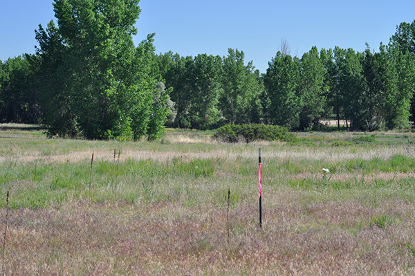
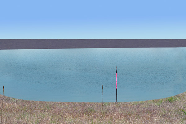
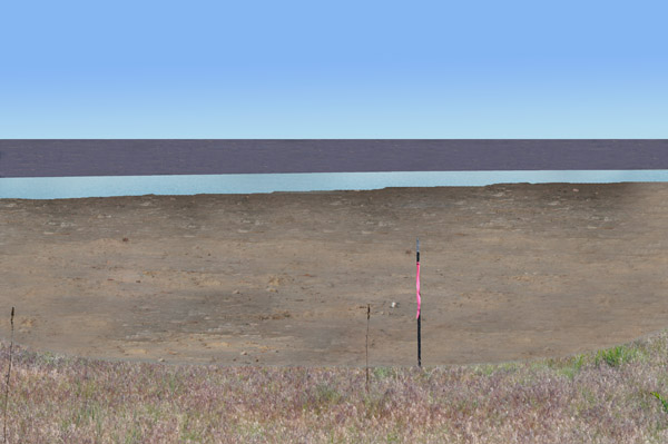
Return to SaveChatfield.org:
Selected Commentary |
Home